Saturday, August 25, 2012

Kaohsiung: A book

A beautifully-designed book I edited recently for Kaohsiung City Government has been printed and distributed. Simply called "Kaohsiung," it introduces the special municipality created in late 2010 by the merger of Kaohsiung City and Kaohsiung County, and includes sections on Kaohsiung's culture, agriculture, fisheries, fruit, sports scene, architectural landmarks and plans for the future. 

Thursday, August 23, 2012

English Emblem 2012

I've just began the latest round of judging visits for the Research, Development & Evaluation Commission's English Services Emblem Project. This year, the team I'm with is set to visit Hsinchu, Keelung and Kinmen. Were it not for the typhoon currently dumping rain on Taiwan, yesterday and today we would have been in Yilan; those inspections have been rescheduled for early September.

Wednesday, August 1, 2012

Dialogues for local government officials

Recently I completed the longest writing project (save for Taiwan: The Bradt Travel Guide, which weighed in at 166,000 words) of my career - a series of dialogues totaling 67,500 words designed to help local government officials introduce their cities and counties to visiting foreign dignitaries. I got to write about a lot of places I know well, and also learned some things about places I'm not so familiar with. The project covered nine areas, including Pingtung County, Hualien County, Taitung County and Hsinchu County. Here's an extract from Chiayi City section:

Foreign Visitor (FV): Is there a nice park near the downtown, somewhere where I can stretch my legs?

Taiwanese official (TO): Yes, there is. Officially it’s called Chiayi Park, but people often call it the Hundred-Year-Old Park because locals have been enjoying fresh air and greenery there for just over a century. Recently the park and the surroundings have been renovated, and you really should take a look around.

FV: What’s there to see? Anything apart from the usual trees, bushes, flowers and benches?

TO: Let talks about those trees and bushes first. Right next to the park is Chiayi Arboretum, which was founded by the Japanese colonial authorities in 1909. The range of trees here is quite wide, because the Japanese imported lots of different species from Southeast Asia, Australia and South America.

FV: Why did they bring in those foreign trees? You told me earlier than Taiwan has a lot of forest. 

TO: They wanted to research which species would do well in Taiwan’s climate. There are mahogany, blackboard and breadfruit trees. The Japanese also planted a lot of rubber trees - more than 1,000 are still there - because the Japanese Army needed lots of rubber during World War II. Apart from trees, there are some special buildings in the vicinity of the park. If the weather is clear, a trip to Chiayi Tower - also called the Sun-Shooting Tower - is a good idea. 

FV: Sun-Shooting Tower? That’s an intriguing name! 

TO: It comes from an aboriginal legend. Traditionally, the Bunun tribe believed that their culture began after they had shot down a second sun, which then became the moon. 

FV: Cute story. How tall is the tower?

TO: Twelve floors or 62m. You can take an elevator to the observation deck at the top and enjoy a cup of coffee while taking in the view...

Thursday, July 19, 2012

Yilan: Sights At The End of The Tunnel (Taiwan Business Topics)

Yilan County has always been a bit different. It is in the east, but fans of Hualien and Taitung belittle it as a Taipei suburb lacking true indigenous culture. To the politically aware, it is the part of Taiwan that was a green-camp stronghold long before the Democratic Progressive Party existed. And few places have had their prospects and character changed so much by a single piece of infrastructure as Yilan has been by the completion of Freeway 5 and the world’s fifth-longest road tunnel.

“One-day tourism is booming,” says Jack Cho, general manager of Toucheng Farm, a leisure farm in the northernmost part of the county. He points out that while the Xueshan Tunnel means residents of Greater Taipei can return home the same day – and are thus less likely to spend money on a hotel room or dinner – at the same time it has made two- or three-day excursions to Yilan much more feasible for residents of central and southern Taiwan. 

Freeway 5 is a godsend for anyone wanting or needing to travel between Yilan and Greater Taipei, yet some drivers find getting on it more difficult than expected. Those starting their journey in downtown Taipei should take Xinhai Road southward until it becomes Freeway 3A (in Chinese, 3甲). This spur is just 5.6-kilometers long and joins the main trunk of Freeway 3 near Muzha. Heading north on Freeway 3, it takes mere minutes to reach the interchange with Freeway 5. Care is necessary, however – just a few hundred meters before the two freeways meet, a quite separate turnoff veers east. Those who take this road will find themselves winding over the hill to Shenkeng on Route 109. Rather than backtrack, anyone who makes this mistake is advised to press on until he or she sees signs pointing them to the Shiding Interchange. 

Drivers coming from further south should be aware that some signs near Xindian that point to Yilan refer to Highway 9 – the old, slow Taipei-Yilan road. Cyclists, as well as those with tunnel phobia or a surplus of time, will find this route a highly scenic alternative. Freeway 5, like Highway 9, enters Yilan County via Toucheng Township. Accordingly, this article focuses on Toucheng and other parts of the county most easily accessed via Freeway 5. During the winter, the hot springs in Jiaoxi are extremely popular, but for those planning warmer-weather excursions, it is less alluring than the city of Yilan or the nearby townships of Luodong, Wujie, and Yuanshan. 

With a population of 73,000, Luodong is Yilan County's largest settlement after Yilan City (which has 95,000 inhabitants). Luodong’s night market is revered by Taiwanese gourmands, but others may find the Luodong Forestry Culture Garden more intriguing. Logging used to be a major industry in the Yilan area, and the garden formerly served as a timber collection and processing plant. The Forestry Bureau began transforming this 16-hectare site into an ecological and industrial-heritage attraction in 2004, and opened it to the public in 2011... 

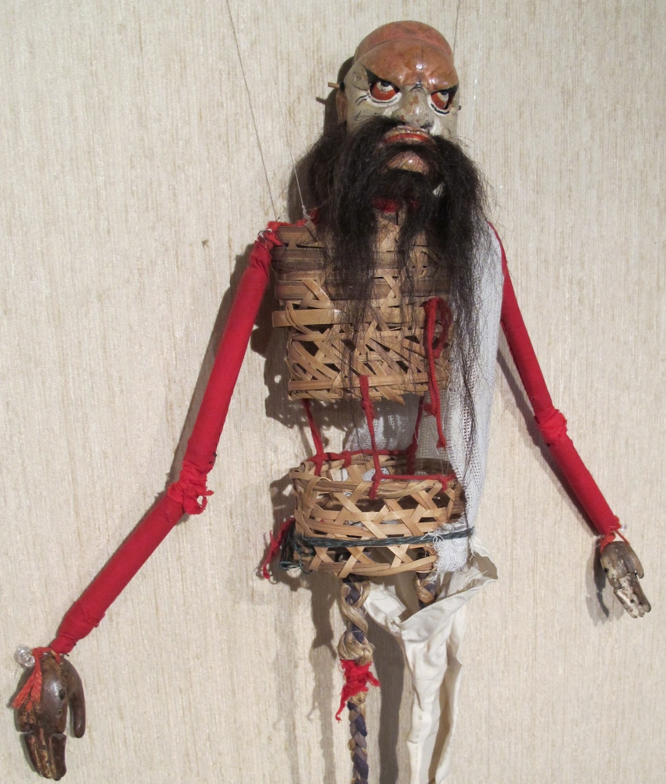
To see the complete article, click here. The photo here shows one of the puppets on display in the county's Taiwan Theater Museum. 

Sunday, July 15, 2012

Out and About in Historic Lukang (Taiwan Business Topics)

Lukang, as every Taiwanese knows, is a place where the forces of modernization have failed to make much of an impression. In terms of architecture and genuine living, breathing tradition, much remains of the old settlement. If anywhere in Taiwan deserves to be called “a living museum,” it is this town, 155 kilometers south from Taipei. 

In middle of last year, Lukang's historical importance received an unusual form of recognition. The Ministry of the Interior decided that because the spelling “Lukang” has been used by non-Chinese since at least 1842, road signs and official documents would continue to use that version, rather than “Lugang” – the town's name when spelled according to hanyu pinyin, the system of romanization adopted by the central government. Road names within Lukang are to be romanized according to hanyu pinyin, but as in many other parts of Taiwan, older signs often show different spellings. 

Lukang’s heyday lasted about 100 years, starting in the middle of the 18th century. During that period it was a population, trading, and shipping center second only to the then capital of Tainan. Until the arrival of the Japanese in 1895, commercial and civic affairs in Lukang were dominated by three clans and eight guilds. According to American anthropologist Donald DeGlopper, who did fieldwork in Lukang in 1967, until the 1930s the three clans – surnamed Shih, Hsu, and Huang – had an unusual way of letting off steam: “The men... would gather every year on one day in the early spring, line up by surname, and throw rocks at their fellows of other surnames... The rock fight was a festive public occasion; women and children watched and cheered; vendors sold snacks. Blood was shed and teeth lost, but no one was ever killed. [Some people] believed that if blood was not shed in the spring, then the community might suffer bad luck during the coming year.” 

Of the eight guilds, one consisted of merchants who traded with Quanzhou in Fujian Province Another comprised those who exported rice and sugar to, and imported timber from, the Kinmen archipelago and the Fujian towns of Xiamen and Zhangzhou. A third guild imported salted fish products from Guangdong and Penghu; the others focused on oil, cloth, dye, sugar, and groceries.

Town elders are sometimes blamed for the passing of Lukang’s glory days. It is said that in the early days of Japanese rule, when the authorities were determining the precise route of Taiwan’s north-south railroad, town leaders lobbied against routing the rail line through Lukang. They failed to understand the economic importance of a rail connection. Perhaps, like 19th-century Chinese, they believed this new, noisy technology would upset the area’s fengshui. 

A look at a map of Changhua County gives this explanation less plausibility. It is unlikely the colonial authorities seriously considered having the railroad veer toward the ocean, and then back inland, to link a town whose harbor had silted up – the main reason for the town’s decline – and whose leading businessmen had begun moving elsewhere...

For an online version of the complete article, click here. For a pdf version with photos, click here. I took the photo here inside the town's Tianhou Temple.

Friday, July 13, 2012

Taiwan's newest museums (Taiwan Business Topics)

Since the 1990s, new museums in Taiwan have, to use a Chinese idiom, been springing up “like bamboo shoots after rain.”

Undoubtedly the most important one to have opened in the past two years is the National Museum of Taiwan History. The opening of this 20-hectare complex last October was a major event – as it should be, because it filled a glaring gap. Taiwan has long had museums dedicated to the arts and sciences, and also to its ethnic minorities; countries of comparable size and wealth have had history museums for decades, if not longer. But Taiwan’s peculiar history has meant that, until quite recently, building a consensus about the past – let alone the island’s future direction – was extremely difficult. 

The project was conceived during Lee Teng-hui’s presidency and nurtured by the Chen Shui-bian administration, but the finishing touches were not made until well after the Kuomintang returned to power in 2008. As a result, many who toured the museum just after it opened were curious to see if it presented a “green-tinted” or “blue-tinged” version of Taiwan’s past.

Anyone looking for a political subtext inside the NMTH will be disappointed, however. The museum has not attracted criticism of the kind leveled at Taipei’s 2-28 Memorial Museum, and it manages to be both thorough and engrossing. The standard of English throughout the NMTH is very high, even if the text is often too small for comfortable reading.

Rather than present history in a traditional text-heavy format, the second floor’s permanent exhibition, “Our Land, Our People – The Story of Taiwan,” is filled with images and models. It goes all the way back to the days of Taiwan's earliest known human inhabitant, “Zuozhen Man,” 30,000-year-old fragments of whom were found in a riverbed about 20 kilometers inland of the museum.

Of the several tableaux vivants on the second floor, two in particular stand out. One is a recreation of Lukang’s waterfront as it would have looked in the 18th century, when the central Taiwan town was one of Taiwan's busiest harbors. The diorama features several lifelike waxworks figures, among them stowaways (who cower in the hold of a single-mast junk, hoping to evade the imperial ban on migrating to Taiwan), the vessel’s captain, stevedores, and an official wearing a traditional mandarin’s gown.

Another depicts a traditional religious parade. Anyone curious about the roles played by Bajiajiang (fierce-looking young men with painted faces who prance menacingly in front of the palanquin bearing the effigy of a god) and others during such events will appreciate the clear and concise information – even if they have to kneel on the floor to read some of the panels.

According to a museum spokeswoman, more than 200 waxwork figures (actually fiberglass) were crafted for the museum, and the physique and face of each one was modeled on an actual living person – including, in one case, NMTH Director Lu Li-cheng.

Elsewhere on the second floor, displays look at the role of irrigation, camphor, and sugar in Taiwan’s development. Financiers will be interested to read that in the mid-1600s, four currencies – Dutch, Spanish, Chinese, and Japanese – were in daily use in those parts of Taiwan controlled by the Dutch East India Company. Exchange rates were, by modern standards, very stable...

To read the rest of this article - which also covers National Taiwan Museum's Land Bank Annex, the Presidential and Vice-Presidential Artifacts Museum, Lanyang Museum (the photo above shows part of an exhibit about Atayal aborigines) and Xiaolin Pingpu Culture Museum - go here. I have three lengthy pieces in this year's Taiwan Business Topics' Travel & Culture Special, and will post the other two in the next few days.

Thursday, July 12, 2012

Havens Apart: Taiwan's Green Island and Lanyu (Unity)

Green Island and Lanyu are similar in some ways – and utterly different in others. Both lie off Taiwan's southeast coast, and both are nubs of solidified magma pushed up by ocean-bottom volcanic eruptions. Also, both are thinly populated. Lanyu has an official population of 4,700, while Green Island has just 3,400 registered residents.

Neither has any industry nor even much farming. This is bad news for the inhabitants – most adults spend several months each year working on Taiwan proper – but it also means the islands are unpolluted. There are no traffic jams, and visitors can find secluded coastal spots where they need not share the sea and sky with others.

Lanyu is unique among the ROC's islands in having an aboriginal Austronesian culture. Green Island's people are of Han Chinese descent, but its history and character have been influenced by those who stayed here unwillingly. Between 1951 and 1990, it was a place of imprisonment for those found guilty of political crimes.

No one can dispute the aptness of Green Island's name. Hilly and verdant, it covers just 15km2 at high tide. At low tide this expands to a little over 17km2 as coral platforms rich in fish, crabs and other creatures are revealed. Snorkeling is the best way to explore this tidal zone, and local tour operators have things set up so even non-swimmers can catch glimpses of what lives in the shallows.

Green Island can be visited as a day trip, although staying at least one night is recommended. Superb scuba diving can be had, especially in the winter when underwater visibility is often 20m. For non-divers, April and May are better months. Temperatures and humidity levels are comfortable, while the strong winds that can make winter ferry crossings unpleasant are seldom a problem.

Most tourists explore the island by motorcycle...

This is part of the article that appears in the July/August edition of Unity, the inflight magazine of UNI Air.